Geography ::
Major Cities:
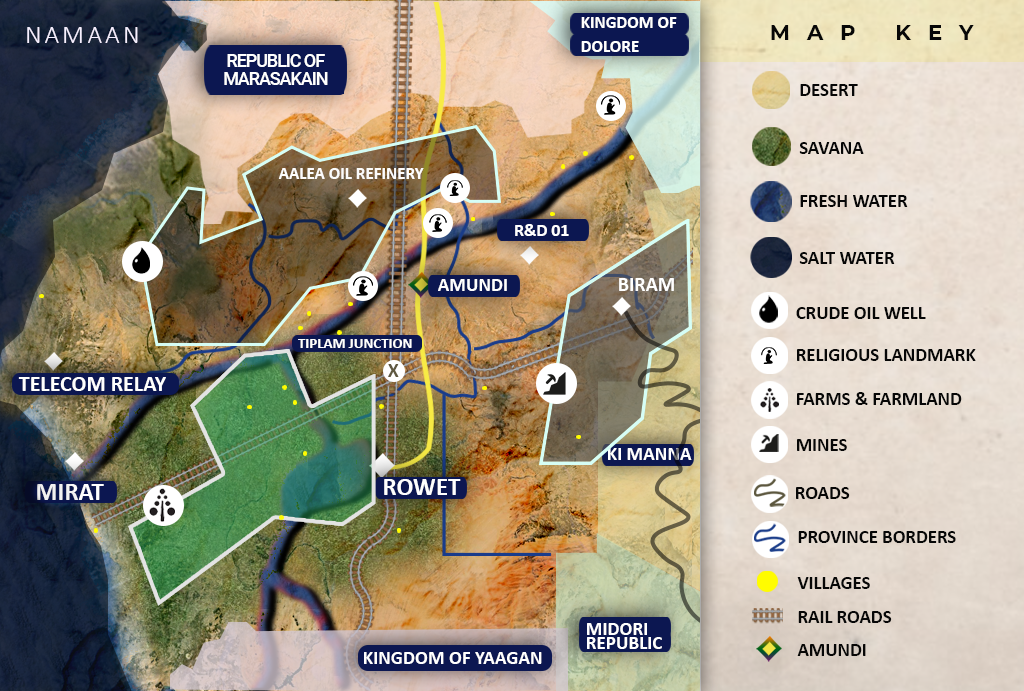
Amundi: The capital city of Namaan is the center of government, culture, commerce and power. Sutulism is the most prevalent religion in Amundi, but some small groups believe in the Ruvosist ideology. The city is an important export hub due to its road, airport, and river access.
Rowet: Southern military command, Rowet is located in the foothills of the southern Yamar mountains on the shore of Rotto lake. Rowet is an industrial city, home largely to factory workers and manufacturing businesses. The Ruvosist religion has a large following in the south, but the free and independent ideology of the South leads to a more secular lifestyle.
Biram: Biram is located near the border of Namaan and Ki Manna. This city is a mining community that excavates the majority of Namaan’s raw materials used for export, manufacturing, and power generation.
Mirat: Located on the Nahron River Delta on the west coast, Mirat is home to the Port of Namaan and coastal military installations. The city consists of mostly dock workers and merchants. Mirat serves as the primary entry point to the country by foreign immigrants.
Provinces:
Kotto (Northeast): This province is the home of a holy site where the ritual for the second son of Sutul was performed. Much of the economy in this province is based on religious tourism, providing travelers with transportation between the holy site and Amundi. The Kotto province is populated by the Ashua and Omoro tribes.
Hokusae (Northwest): Has two major ports, and large reserves of crude oil. This province is associated with the Aburoy and Ashua tribes.
Shamal (Central north): Houses the capital Amundi and is considered the birthplace of Sutulism. Many Sutulists from across the world travel to this province to visit the many holy sites in the area. Also provides Namaan with a considerable amount of oil. Tiplam junction resides in the southern border of Shamal. The Ashua tribe is dominant in this province.
Aalea (Upper north): Home to major oil reserves that are utilized by northern petroleum companies and the one oil refinery in the country. Primarily populated by the Ashua Tribe.
Bunaj (Central south): Home of Rowet this province mainly consists of the Iasaam tribe, and is the heart of manufacturing in Namaan.
Qurashal (Southeast): This mountainous province is home to the Omoro tribe and Namaan’s mining operations.
Brahg (Southwest): The agricultural hub of Namaan, the rivers in this province make this land ideal for farming. Consists mostly of Aburoy and Iasaam tribes.
Points of Interest:
Port of Namaan: One of the few major shipping ports for surrounding countries, the Port of Namaan is key to the economic development of the country.
Powerplant: The power plant is located in Biram and fueled by coal. It is one of two sources of power supplying the city of Rowet and the surrounding villages.
Tiplam Junction: Tiplam junction sits at the intersection of all railroads in Namaan. The junction is the primary hub for transporting goods across the country and exports from neighboring countries. This junction is a key intersection for supplying Northern and Southern armies.
Telecom Relay: The Telecom Relay, located 50 miles (80 Kilometers) north of Mirat, is a key point in the communication network for the southern cities in Namaan. This relay is important for civilian communication as well as communication for emergency services.
R&D 01: A secret research facility for northern technology, weapons and military use. It is controlled by the north and heavily guarded.
Aalea Oil Refinery: The only oil refinery in Namaan was built to give Namaan a degree of self-sufficiency. The majority of refined oil is still imported to the country.
Rotto River Dam: The dam located between Rotto River and Rotto Lake provides a source of renewable energy to Rowet and southern Namaan.
Amundi Airport: This is the only commercial Airport in Namaan. Located east of the Namaan highway just outside of Amundi.
Namaan Highway: Still in its early development, this highway runs from Rowet to Murasakain and consists of mostly rough uneven pavement and frequent potholes. The highway has exits leading to Amundi, the Biram Highway, Tiplam junction and the Aalea Oil Refinery
Geographical Features:
The Yamar Mountain Range: The Yamar Mountain Range extends from the north east of Namaan to the south bordering the countries of Dolore, Ki Manna, Midori and Yaagan. The population in this region is scattered, and it consists almost entirely of the Omoro tribe and coal miners.
The Nahron River and Rotto lake: The Nahron River flows from the north east corner of Namaan across where it is joined by the Rotto river and eventually empties into the Indian Ocean. The Nahron River allows a vibrant farming culture in the surrounding area.
Countries connected to this river pay Amundi a toll to access the indian ocean and trade overseas. Rotto lake is a natural basin which collects the water of the Rotto River, and then continues into the larger Nahron River. The dam placed between the Rotto river and Rotto lake provide the south with a secondary source of power.
The Siccum Desert and Southern Savanna: The Siccum Desert covers most of the northern territory of Namaan with some small forest along the southern coast. The majority of the country’s interior consists of arid, rocky dessert, and sandy grassy plains. Large oil reserves are found in the northern Siccum desert which have been utilized and refined by industries in Amundi. Savanna sprawls across the southern half, made green by the rivers and the lake where agriculture thrives.